
There is no point to reaffirm yet again that maps are the instruments of power, and that space is not given but produced.[1] Over the recent decades, those once groundbreaking claims of the critical cartography, which drew on Foucault’s discourse analysis and Derrida’s deconstruction, have already gained the status of the established truths. Today they are both contested and supplemented by the new post-constructivist approaches to the map, which redefine it as a process rather than a product, contingent, corporeal and performative.[2] The theoretical discourse about cartography has seldom focused on the eastern peripheries of Europe, where the map, both as a tool of power-knowledge and a script of resistance constitutes an intrinsic component of the region’s identity. Not only does it precede the territory, but it is routinely chosen as the area’s ur-metaphor. The post-WWI launch of the first ‘cartographic mandate’ of the region, identified the area with a bunch of the ‘small states of Europe’, drawn by ‘the mapmakers of Versailles’ on the bodies of the collapsed empires.[3] The subsequent arbitrary gesture of reshaping the map of Europe in Yalta, conjured up both the territory behind the Iron Curtain and a whole range of competing geographical metaphors, from the ‘Communist Bloc’ to the ‘Kidnapped Europe’.[4] Even if not preceded by the map, the ‘Fall of the Wall’, an instant metaphor on its own right, was hastily followed by the influx of new maps and atlases, redefining the boundaries and the physical make-up of the eastern periphery Europe that has emerged from behind the wall’s ruins.[5] Symptomatically, the map features as the central metaphor of Yuliya Komska’s collection of texts, Eastern Europe Unmapped: Beyond Borders and Peripheries, which emphatically aims to ‘unmap’ Eastern Europe.[6] Thus, regardless of the attempts to move beyond it when rethinking the East Central European area studies, the map is here to stay, and it is in a need of critical interrogation. The intermediality of the cartographic language, utilising both text and image, makes it particularly open to the interdisciplinary inquiry from social sciences and humanities. One of the less explored avenues of further research is offered by visual studies. If the map precedes the territory, is it the image that precedes the map?
Almost forty years ago, one of the founders of the critical cartography Brian Harley, in order to advance his critique of the map, turned to the methods of art history, and specifically to Erwin Panofsky’s method of iconology.[7] In his later texts, notably in his canonical ‘Deconstructing the Map’ (1989), Harley’s conceptualisation of the map as an image drew from a new approach to the domain of the visual, proposed in W.J.T Mitchell’s Iconology: Image, Text, Ideology (1986).[8] The latter was one of the founding texts of visual culture, which contested the positivist aims of art history, and was developed in parallel to the critical cartography, sharing its social constructivist outlook, attention to exclusion, as well as commitment to theory.[9] Visual culture’s embracement of all kinds of imagery and technologies of vision, including art, popular culture, science, information, as well as cartography, opened up a possibility to inform the existing scholarly engagement in rethinking the map.[10] Harley’s interdisciplinary gesture, however, has hardly been followed. If the ‘artness’ of cartography attracted much attention from the cartographers themselves, as well as cultural geographers and artists,[11] the ‘artless’ mechanisms of visuality as the modus operandi of any map, failed to ignite the debates in a comparable way.[12] The traffic between visual culture and cartography is still pretty slow, punctuated by occasional calls for a more intense dialogue.[13]
The image activates the map, and the map activates the image. The territory plays a secondary role in this game. Likewise, cartography, critical art history and visual culture travel along parallel routes, rub shoulders with each other, raise similar doubts, and benefit from casting a glance over each other’s doing.
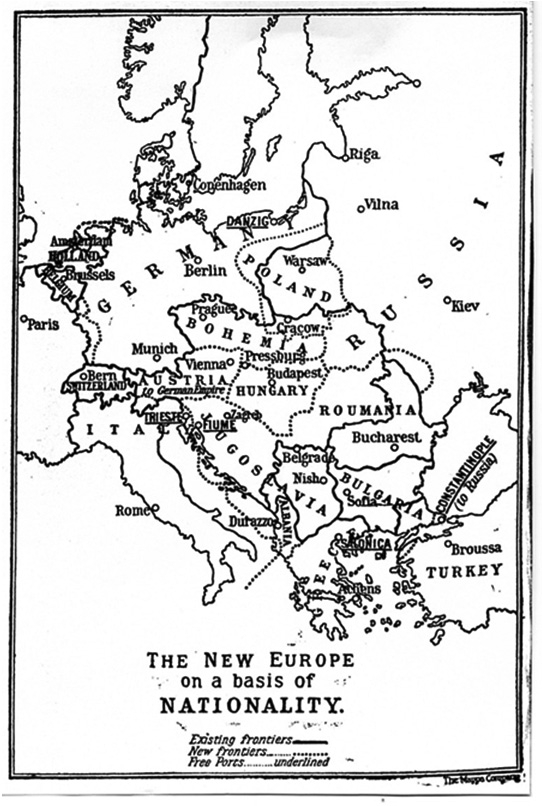
Looking at maps of East Central Europe, this short text will approach them as images, using the methods of visual analysis, and following insights from the field of cartography and visual culture. It will focus at a large map of Slavic Europe, published by the Slavonic philologist Pavel Josef Šafařík in 1842[14], and a small thematic map The New Europe on a Basis of Nationality, an illustration in the book on the origins of the Great War (1916), authored by another prominent Slavist, the historian R.W. Seton-Watson, the founder of the School of Slavonic and Eastern European Studies, and known in fact as ‘the maker of a New Europe’.[15] Can visual analysis uncover unwritten affiliations and aspirations, affections and aversions, which are activated by those maps, and which are likely to escape other kinds of analytical approaches? Or, more broadly, can visual culture contribute to the process or rethinking the area studies of East Central Europe?
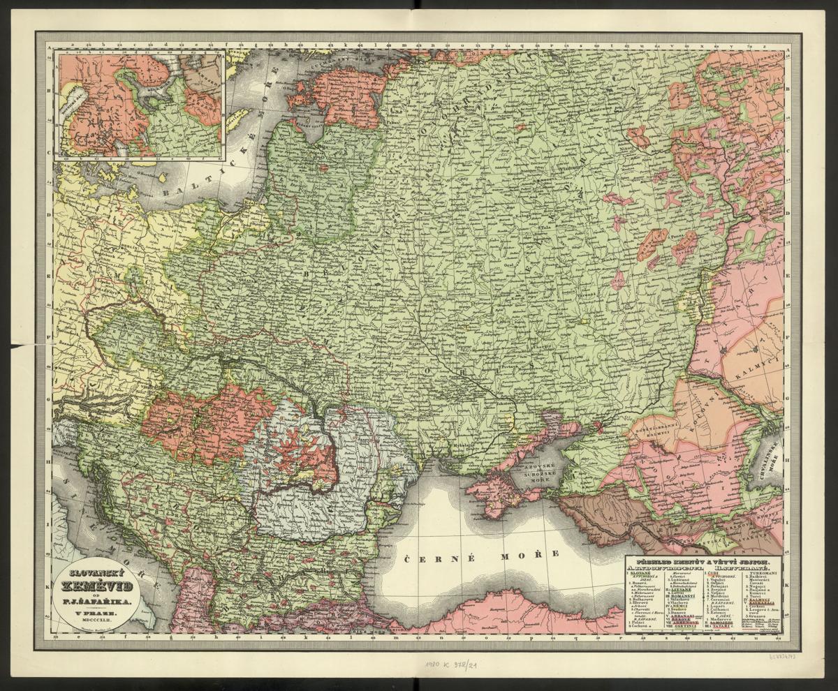
Both maps advance arguments about the spatial dimension of East Central Europe, and both are propositional in nature. They aim to activate the territory, and are driven by emancipatory aims. Slovanský zeměvid is a pioneering and unprecedented cartographic vision of the region of Eastern Europe, which never before has been presented as a separate space, worthy of its own map.[16] Painstakingly prepared by Šafařík over many years, it reclaims the region occupied by the Great Empires as an imagined linguistic community of Slavs. By contrast, an inconspicuous map The New Europe on a Basis of Nationality, published by Seton-Watson 60 years later, during the Great War, could count as a next step of this pro-Slavic manifesto.[17] It presents an idealist vision of the post-WWI Europe, in which once enslaved nations of East Central Europe would be liberated and granted their own state borders, the vision soon to be turned into reality at the Parisian Peace Conference.
The cartographic gaze, the mapmaker’s commanding view from above, so clearly implied here, is a particular instance of the disembodied gaze, controlling access to knowledge and power. The vastness of the Slavic land is enhanced by the use of colour, and the same shade of green stands for all Slavic people, without any divisions into Northern, Western or Southern.
In spite of the affinities of the mapmaker’s agendas, the maps differ in almost every respect: the historical circumstances of their production, the area covered, the medium, dimensions and format, their targeted audiences and impact, as well as their kinship to a broad family of images. Slovanský zeměvid, engraved in colour by the graphic artist and cartographer Věnceslav Merklas, is a regular cartographic document, belonging to the genre of ethnographic surveys, popular in the nineteenth century, and habitually included in geographical atlases.[18] Its cartographic basis was provided by a series of topographical maps of Europe, made for the Prussian army by the German cartographer Daniel Gottlob Reyman, and known for their exceptional accuracy.[19] The names of all sites are demonstratively turned to Slavonic, and spelled in Czech, including those of German sites. The name of the map is rendered in strikingly ornate lettering, using several fonts, of different scale, which evoke Slavic ornaments. Equally elaborate legend lists all the ethnic groups represented, classified by their languages, and asserts Slavs’ domination over the region, both within the group of Indo-European peoples (Lithuanians, Romanians, Germans, Bulgarians, Greeks, Armenians and Ossetians) and ‘the Northerners’ (the Uralic people, Tatar, Turkish, Kalmykian and Caucasian).[20] Published initially in 600 copies, the map did not function on its own, however, but was attached, in a Baedeker manner, as a fold out to Šafařík’s Slovanský národopis (Slav Ethnography), his popular survey of Slavic languages and folk songs.[21]
By contrast, The New Europe is a small thematic map, made of lines and dots. Even though also included in the book, it was no more than an illustration on a page. The signature of ‘The Mappa Company’, under its frame indicates that Seton-Watson must have also used a ready-made map of Europe, a very rudimentary one, to which he added the proposed boundaries of the new states. The New Europe does not aspire to cartographic accuracy, but would not give up on its rhetorical potential. Driven by the anti-Germanic spirit, it was directed against the spectre of Mitteleuropa, revived by Friedrich Naumann’s in 1915.[22] A small legend at the bottom, indicating the ‘existing’ and ‘new’ frontiers, plus ‘Free Ports’, and especially its overblown title, which is clearly vying for attention, form an important part of the image, emphasising its manifesto-like message, a project of a ‘regenerated’ Europe.
The intermediality of the cartographic language, utilising both text and image, makes it particularly open to the interdisciplinary inquiry from social sciences and humanities. One of the less explored avenues of further research is offered by visual studies. If the map precedes the territory, is it the image that precedes the map?
If Seton-Watson’s map was buried in the book, to be seen by his fellow historians and perhaps by Versailles mapmakers, Šafařík’s map attracted an incomparably wider audience. Slovanský národopis went through at least two editions in the first year, and was immediately translated into Polish and Russian, in the latter case including the map.[23] The book’s mains attraction was indeed the map, which literally activated an imagined community of the Slavs, prompting the wave of ethnic pilgrimages across Slavic countries. Stanko Vraz, a leader of the Illyrian movement, recorded its totally unprecedented impact: ‘When I brought a copy of this map, the local patriots and even non-patriots almost tore it out of my hands. All of them cannot get over the fact that the Slav nation is spread so far. The map arouses more patriots here than a whole literature could do.’[24] And indeed, literally superimposed on the cartographic matrix of Mitteleuropa, and vested in the Herderian glorification of the language and folk culture, Slovanský zeměvid was a conscious act of counter-mapping, a powerful script of cultural resistance, a rallying call for Panslavism. [25] It set up the cartographic code to represent the region, adopted in Spruner and Berghaus atlases, and disseminated throughout the nineteenth century.[26] The effectiveness of the map stemmed first and foremost from its visual rhetoric, sanctioned by the authority of the cartography. As testified by Vraz’s enthusiastic account, the map provided an image of an inhabitable Slavic collective identity, of the desirable Slavonic Self, but also a visible record of Slavic power. The act of unfolding the map was tantamount to the discovery of the legitimacy of Slavic Europe, spreading from Berlin to the Urals.
The physical features of the territory were largely deemphasised, but much of the rhetorical power of the map came also from its association with landscape, widespread, uniformly green, agrarian, and welcoming. The Czech term ‘zeměvid’ which means ‘map’, is also a compound of ‘země’, land, and ‘vid’, aspect, thus connoting the act of viewing a land. The affinity between map and landscape is one of the much discussed topics by cultural cartography, as well as in visual culture, both pointing to the tension between the aesthetic values of landscape as an artistic genre and claims to ownership of the land it represents, whether on the part of landed gentry, or the communities which defend their shared territory, and their ethno-cultural links to the soil.[27] It is from this perspective that Slovanský zeměvid reveals its double nature, emancipatory and discriminatory at the same time. The cartographic gaze, the mapmaker’s commanding view from above, so clearly implied here, is a particular instance of the disembodied gaze, controlling access to knowledge and power.[28] The vastness of the Slavic land is enhanced by the use of colour, and the same shade of green stands for all Slavic people, without any divisions into Northern, Western or Southern. While the linguistic boundaries between the Slavs are marked by the dainty lines made of dots, the thick state borders of the occupiers highlighted in red resemble instead scars on the Slavic body. At the same time, the isolated areas inhabited by non-Slavs, such as Hungarians and Romanians, let alone Germans, are rendered in yellow, and in garish shades of pink, which clash and distort the sense of serenity conveyed by the relaxing hues of green.[29] The use of Slavic names restored and confirmed the Slavic rights to the land in much the same way in which German names on the maps of Mitteleuropa were giving authority to Teutonic expansion. Inclusion is always, and inevitably, related to exclusion. The counter-map turns into the map of domination.
R.W. Seton‐Watson, “The New Europe on the Basis of Nationality” in German,SlavandMagyar ‐ AStudyintheOriginsoftheGreatWar(London: Williams and Norgate, 1916), 146.
Seton-Watson’s map presents an entirely different image. In spite of its relative obscurity, it did contribute to the rise of a new cartographic regime of representing East Central Europe in the totally changed political configurations in the midst of WWI. By then, Panslavism has already been compromised as a tool of Russian expansionism.[30] The New Europe had to exclude Russia, absorbing instead all the countries liberated from imperial subjugation, including both Slavic and non-Slavic. A new cartographic code was needed, in fact, a new image which would abandon the rhetoric of vastness, horizontality, and cultural affinity stemming from linguistic commonality, and generate a new common denominator for these diverse European states. Leaving aside the issue of boundaries, which reflect Seton-Watson’s pro-Czech and anti-Hungarian sympathies, in The New Europe, the horizontal format of landscape, no longer either suitable or tenable, was now replaced by the vertical format of portrait. This had to incorporate a whole cluster of yet-to-be- established political bodies within the narrow stretch of land separating Germany from Russia. Slavic vastness shrivelled to a narrow belt of Zwischeneuropa.[31] From the critical cartography perspective, Seton-Watson’s New Europe is a striking example of an arbitrary ‘geo-body’, Winiachakul’s term for the colonial cartographic invention of the still unmapped territory of nineteenth-century Siam, undermining the validity of local knowledge and generating its own historical narrative.[32]
There is no doubt, of course, that Seton-Watson’s New Europe was intended as emancipatory, restoring sovereignty to the oppressed nations, and its vertical format simply corresponded with their position on the map of Europe. However, as in Šafařík’s map, it was the rhetorical power of the image itself, which invested the map with additional layers of meaning, and activated its socio-political status in the twentieth century. The genre of portrait, as much as landscape, makes various extra-aesthetic claims pertaining to the social status and power of the sitter. Its subspecies, the group portrait comments also on the relationship between individuals, emphasising the marks of their shared identity, based on legal contract, blood ties or social affiliation. [33] Most often, it uses the horizontal format of a multi-figure composition and, like a single portrait, is essentially celebratory. The most evocative feature of Seton-Watson’s New Europe, however, is the disparity between the conventions of a group portrait and a single portrait frame. Thus, in contrast to its celebratory caption, it shows an anxiety-ridden image of a chaotic array of the news states, small and insecure within their unfixed boundaries, and crowded uncomfortably one on top of another. What they share, the image seems to say, is their ‘newness’, smallness, instability, and propensity to discord. Another significant feature of The New Europe is the suggestion of its separateness. The new states seem to occupy an isolated region, which, in order to be represented, had to be excised from the map of the continent and framed as an independent territory, that of the ‘New Europe’, the ‘shatter zones’, the ‘middle tier, or ‘the belt of political change’, positioned in between Europe and Asia.[34]
The theoretical discourse about cartography has seldom focused on the eastern peripheries of Europe, where the map, both as a tool of power-knowledge and a script of resistance constitutes an intrinsic component of the region’s identity. Not only does it precede the territory, but it is routinely chosen as the area’s ur-metaphor.
If Slovanský zeměvid prompted the long-standing regime of representing Eastern Europe as bound to Russia, revived during the Cold War, Seton-Watson’s map established another enduring cartographic trope which, endlessly repeated until the new millennium, naturalised into the most suitable way of understanding of East Central Europe, disseminating the same message of inherent political instability and inherent narrative of fragmentation. Both were intended as maps of resistance, and both were liable to be read also as the visual documents of domination and subjugation. As I argued, it was their affinities to landscape and portrait that contributed to their visual opacity and ambiguity, generating oppositional readings.
Mapmaking and image making are parallel processes, both at the level of production and consumption. Maps and images are in constant dialogue, borrow from each other, develop against each other, correct and supplement their visual accents, ‘foci, zooms, their highlights, their blinkers and blindnesses.’[35] The image activates the map, and the map activates the image. The territory plays a secondary role in this game. Likewise, cartography, critical art history and visual culture travel along parallel routes, rub shoulders with each other, raise similar doubts, and benefit from casting a glance over each other’s doing. East European area studies have an unexhausted potential to contribute.
The text was firts published in the Book The New Dictionary of Old Ideas (2020).
[1] J. B. Harley, The New Nature of Maps: Essays in the History of Cartography, ed. Paul Laxton, introduction by J. H. Andrews (Baltimore, Maryland: The John Hopkins University Press, 2001).
[2] See The Map Reader: Theories of Mapping Practice and Cartographic Representation, ed. Martin Dodge et al. (London: John Willey & Sons, Ltd, 2011).
[3] Eric Hobsbawm, Age of Extremes: The Short Twentieth Century 1914-1991 (London: Abacus, 1995), 31-32. Recently, Steven Seegel, Map Men: Transnational Lives and Deaths of Geographers in the Making of East Central Europe (Chicago and London: Chicago University Press, 2018).
[4] According to reports, the first act of the WWII squabbling about the territory of Europe took place in Teheran, where during the final plenary session in December 1943 ‘the British and ‘Russians were working on a map of Poland torn from The Times of London’. Charles E. Bohlen, Witness to History, 1929-1969 (New York: Norton, 1973), 152-53. Milan Kundera, “The Tragedy of Central Europe”, New York Review of Books, 26 April 1984, 33-38.
[5] Richard and Ben Crampton, Atlas of Eastern Europe in the Twentieth Century (London: Routledge, 1996); Paul Robert Magosci, Historical Atlas of Central Europe: From the Early Fifth Century to the Present (London: Thames and Hudson), 2002.
[6] Yuliya Komska, “Introduction: A Discontiguous Eastern Europe,” in Eastern Europe Unmapped: Beyond Borders and Peripheries, ed. Irene Kacandes and Yuliya Komska (New York and Oxford: Berghahn Books, 2018), 1-28.
[7] J. B. Harley, “Texts and Contexts in the Interpretation of Early Maps (1980),” in The New Nature of Maps, 37.
[8] J. B. Harley, “Deconstructing the Map (1989),” in The New Nature of Maps, 149-167. J.W.T. Mitchell, Iconology: Image, Text, Ideology (Chicago and London: University of Chicago Press, 1986).
[9] See W.J.T Mitchell, Picture Theory: Essays on Verbal and Visual Representation (Chicago and London: Chicago University Press, 1994). Recently, Sunil Manghani, Image Studies: Theory and Practice (London: Routledge, 2012).
[10] James Elkins, The Domain of Images (Ithaca and London: Cornell University Press, 1999), 223-235.
[11] Art and Cartography: Six Historical Essays, ed. David Woodward (Chicago and London: University of Chicago Press, 1987); Denis Cosgrove, “Maps, Mapping, Modernity: Art and Cartography in the Twentieth Century,” Imago Mundi 57/1 (2005), 35-54.
[12] An exception is Gillian Rose, see for instance her “On the Need to Ask How, Exactly, is Geography ‘Visual’”, Antipode 35 (2003), 35, 212-221. Her book Visual Methodologies: An Introduction to Interpretation of Visual Materials (London: Sage, 2001), does not give much attention to cartography.
[13] Martin Dodge et al, “Mapping Modes, Methods and Moments: A Manifesto for Map Studies,” in Martin Dodge et al, Rethinking Maps: New Frontiers in Cartographic Theory (London and New York: Routledge, 2009), 225. See also my comparison between the visual strategies of cartography and caricature, Katarzyna Murawska-Muthesius, “Mapping the New Europe: Cartography, Cartoons and Regimes of Representation,” Centropa 4/1 (2004): 5-19.
[14] Pawel Josef Šafařík, Slovanský zeměvid, in Slovanský Národopis, s mappau (Prague: Wydawatele, 1842). On Šafařík, see J.M. Kirschbaum, Pavel Jozef Šafárik and his contribution to Slavic Studies (Cleveland, Ohio: The Slovak Institute, 1961); Ján Tibenský, Pavol Jozef Šafárik: Život a dielo (Bratislava: Osvetový ústav, 1975); Personálna bibliografia Pavla Jozefa Šafárika, ed. Miloš Kovačka et al. (Martin: Slovenská národná knižnica, 2004). Šafařík’s name is spelled differently in Czech and Slovak. I am following the original transcription of his name, as on the title page of his book.
[15] R.W. Seton-Watson, The New Europe on a Basis of Nationality, in German, Slav and Magyar – A Study in the Origins of the Great War (London: Williams and Norgate, 1916), 146. On R.W. Seton-Watson, see Hugh and Christopher Seton-Watson, The Making of a New Europe: R.W. Seton-Watson and the Last Years of Austria-Hungary (London: Methuen, 1981).
[16] Josef Hůrský, “Vznik a Poslání Šafaříkova Slovanského Zeměvidu,” in Slovanský Národopis, ed. Hana Hynková in cooperation with Josef Hůrský and Luboš Řeháček (Prague: Československá akademie věd, 1955), 218-288.
[17] R.W. Seton-Watson, German, Slav and Magyar. See also Peter Bugge, “‘Shatter Zones’: The Creation and Recreation of Europe’s East,” in Ideas of Europe since 1914: The Legacy of the Frist World War, ed. Menno Spiering and Michael Wintle (Basingstoke and New York: Palgrave Macmillan, 2002), 49-54.
[18] Walter Goffart, Historical Atlases: The First Three Hundred Years 1570-1870 (Chicago and London: University of Chicago Press, 2003); Jeremy Black, Maps and History: Constructing Images of the Past (New Haven and London: Yale University Press, 1997); Tomasz Kamusella, “School History Atlases as Instruments of Nation-State Making and Maintenance: A Remark on the Invisibility of Ideology in Popular Education,” Journal of Educational Media, Memory, and Society 2/1, 2010, 113-138.
[19] Šafařík, 5; Hůrský, 229.
[20] On the representation of Lithuania on the map, see Vytautas Petrois, Constructing Lithuania: Ethnic Mapping in Tsarist Russia, ca. 1800 -1914 (Stockholm: Acta Universitatis Stockholmiensis, 2007), 176-184.
[21] Hůrský, 218-288. On Slovanský Národopis, see chapters by Hana Hynková, “O významu Šafaříkova ‘Slovanského národopisu’ pro slovanskou etnografii,” and Luboš Řeháček, “Slovanský národopis s hlediska filologického,” in Slovanský Národopis 1955, 183-197 and 198-217, also K. Murawska-Muthesius, “Mapping Eastern Europe: Cartography and Art History,” Artl@s Bulletin 2/2 (2013), 19-21.
[22] Friedrich Naumann, Mitteleuropa (Berlin: Georg Reimer, 1915). Seton-Watson’s book includes one more map, which warns against the ‘Pan-German Plan’ of conquering the East, in historical stages. R.W. Seton-Watson, German, Slav and Magyar, 175. See also Bugge, “‘Shatter Zones’,” 48-49.
[23] P.J. Szafarzyk, Słowiański Narodopis, trans. Piotr Dahlman (Wrocław: P.Schletter, 1843), and P.J. Szafarik, Slavianskoe narodopisan’e, z kartou, trans. O. Bodianski (Moscow: Universitetskaia Tipografia, 1843).
[24] Hanks Kohn, Panslavism, Its History and Ideology (Notre Dame, Indiana: Notre Dame University Press, 1956), 14. See also Wendy Bracewell, “Travels Through the Slav World,” in Under Eastern Eyes: A Comparative Introduction to East European Travel Writing on Europe, ed. Wendy Bracewell and Alex Drace-Francis (Budapest and New York: Central European University Press, 2008), 147. Recently, Ivo Vukcevich, Croatia 3: New Language, New Nationality and New State (Bloomington, Indiana: Xlibris, 2013), 57.
[25] The First Slavic Congress in Prague in 1848 opened with Šafařík’s speech – Stanislav J. Kirschbaum, Historical Dictionary of Slovakia (Lanham, Maryland, Toronto and Plymouth: The Scarecrow Press, 2007), 253.
[26] “Die Völker und Reiche der Slaven zwischen Elbe und Don bis 1125,” in Karl Sprunner, Historisch-Geographischer Hand-Atlas zur Geschichte der Staaten Europas von Anfang des Mittelalaters bis auf die neueste Zeit (Gotha: Justus Perthes, 1846); Übersicht von Europa mit ethnograph. Begränzung der einzelnen Staaten, in Heinrich Berghaus, Physikalischer Atlas (Gotha: Justus Perthes, 1848), vol. 2.
[27] See John Barrell, The Dark Side of the Landscape: The Rural Poor in English Paintings 1730-1840 (Cambridge: Cambridge University Press, 1980); Landscape and Power, ed. W.J.T. Mitchell (Chicago and London: Chicago University Press, 1994). Denis Cosgrove, “Introduction: Landscape, map and vision”, in Geography and Vision: Seeing, Imagining and Representing the World (London: I.B. Tauris, 2008), 1-12.
[28] On the cartographic gaze, see Gillian Rose, Feminism and Geography: The Limits of Geographical Knowledge (Cambridge: Polity, 1993), 108; John Pickles, A History of Spaces: Cartographic Reason, Mapping and the Geo-coded World (London and New York: Routledge, 2004), 75-91.
[29] As confirmed in Šafařík’s papers, the choice of colour was loaded with significance, and green was associated with hope. Hůrský, 220.
[30] Comic maps of Europe, such as those by Paul Hadol or Fred W. Rose, adopted the boundaries of the Slavic Europe to comment on the voraciousness of the Tsarist Empire. On the satirical maps of Europe, see Roderick M. Barron, “Bringing the Map to Life: European Satirical Maps 1845-1945,” Belgeo: Revue belde de géographie 2-4 (2008), 1-17.
[31] The term Zwischeneuropa initiated by Albrecht Penck as one of the descriptions of Central Europe (Robet Sieger and Albrecht Penck, “Zwischeneuropa?,” Zeitschrift der Gesellschaft für Erdkunde zu Berlin (1916), 177-80), was adopted as a pejorative name of the new states. See David Thomas Murphy, The Heroic Earth: Geopolitical Thought in Weimar Germany, 1918-1933 (Kent, Ohio and London: The Kent State University Press, 1997), 144, 148-149; Bugge, “‘Shatter Zones’,” 58.
[32] Thongchai Winiachakul, Siam Mapped: A History of the Geo-Body of a Nation (Chaing Mai: Silkworm Books, 1996), excerpts reprinted in The Map Reader, pp. 407-411.
[33] Shearer West, Portraiture (Oxford and New York: Oxford University Press, 2004), esp. 105-106
[34] Murawska-Muthesius, “Mapping the New Europe”, 14-15.
[35] Gillian Rose, ‘On the Need to Ask”, 213.